
Geotechnical Engineering has been the core service of our company for many years providing specialist consultancy services throughout New Zealand and the Pacific. Ever changing complexity of projects demands our involvement in the project from the start to final inspections including close cooperation with other consultants and contractors.
Soil & Rock has a team of highly experienced geotechnical engineers, engineering geologists, computer modellers and geotechnical design experts which offer their expertise through all stages of the project starting with field investigation, computer analysis, interpretation and design, construction inspections and certification.
Providing a diverse range of geotechnical services to our clients our involvement in many projects starts at initial concept, and includes investigation, design and construction observations.

Field Investigations
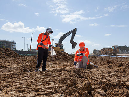
Field investigations are performed by our specialist field staff and the site specific results are analysed by our qualified and experienced geotechnical engineers and engineering geologists. We obtain in-situ information on the physical properties of soil and rock and collect samples for laboratory testing to provide geotechnical design recommendations for earthworks and various types of structures.
All our sites have a site specific health and safety plan, field brief and scope and our team of professionals carry out a range of testing methods to gather data including:
Hand auger drilling
Scala penetrometer testing
Cross sections and GPS surveying
Logging of machine drilled rotary core boreholes
Logging of machine drilled percussion boreholes
Logging of machine excavated test pits
Geomorphologic mapping
Laboratory testing
Clegg hammer testing
Nuclear densometer testing
Soil contamination sampling
Groundwater monitoring
Cone penetrometer test (CPT)
Shear vane testing

Geotechnical Design
Our geotechnical design team consists of highly experienced Geotechnical Engineers who play a vital role in the early planning and design stages of a project. Construction inspections, performance monitoring and a hands-on approach are equally important for the successful completion and engineering sign-off of the projects we work on. Our key focus is on the design of earth retaining structures, ground improvement techniques and slope engineering fields of practice, with the in-house capability and expertise to design anything from small through to large scale commercial and infrastructure projects.
Our qualified engineers and geologists provide the following services:
Timber pole / barrier pile retaining wall design
Mechanically stabilised earth (MSE) wall design
Soil nailing design
Rock slopes support and rock fall barriers design
Ground improvement methods design
Reinforced embankments design
Peer review of design
Wetland / pond design
Groundwater control methods design
We own a complete suite of analytical tools that allow detailed design and preparation of construction drawings in a timely manner. We use the latest specialist software packages available in the market to perform routine, conventional geotechnical analysis but also numerical / finite element analysis should this be required for projects of increased complexity. Indicative software packages that we use include PLAXIS 2D (Static & Dynamic), SLIDE, WALLAP, MSEW, Phase2, Settle3D, CPeT-IT, CLiq, Rocfall and MODFLOW.
Our design team are fully versed in using the software having attended advanced courses in computational geotechnics and Soil Dynamics and Soil Engineering.
Disclaimer: We provided the geotechnical input for the above retaining wall but were not involved in the geotechnical design.

Engineering Geology
Our engineering geologists prepare and use geologic and geomorphologic mapping, aerial photograph interpretation, rock face assessments and various other investigative methods to develop a geological or geotechnical model of a site. Our engineering geologists work closely with our geotechnical engineers to analyse and form recommendations relating to a specific hazard or development proposal.
Work commonly carried out by our engineering geologists includes: mapping of rock defects and analysis of rock mass properties, rockfall analysis and design input for rockfall mitigation and assessment of natural hazards for land development. Our dedicated engineering geologists are often found dangling from abseiling equipment, or near a drilling rig getting their hands dirty!
Our qualified engineers and geologists provide the following services;
Assessment of geologic and geotechnical hazards including remediation solutions for natural and man induced hazards
Engineering geologic and geomorphologic mapping
Landslide and slope stability
Erosion, flooding, dewatering, runoff assessments
Rock face and defect mapping
Cliff stability studies
Hydrogeological studies
Seismic investigations and liquefaction assessments
Construction Monitoring & Inspections
We have dedicated inspections and earthworks teams who are readily available to assist you or your clients during the construction phase of your work for;
Earthworks Monitoring
Nuclear Densometer testing and Scala Penetrometer testing
Construction inspections
Earthworks completion reports and
Certification during construction
Our project engineers are actively involved with our inspections teams in the construction phase of the work to ensure our recommendations specified in our report flow through to the construction phase and your project runs smoothly.
On conclusion of the inspections phase we provide a comprehensive detailed account of what we inspected and final certification for your project to obtain your signoff with local authorities. With strong management controls and well developed quality assurance procedures we ensure consistency and high quality in our monitoring & inspections.

Slope Stability
We carry out analysis of slope stability for various purposes. These include assessing the risk of slope movement for proposed or existing building platforms and carrying out forensic analysis on slopes that have already experienced either recent or historic instability.
Common forms of slope instability are often described as landslides, land slips, slumps and debris flows.
The results of slope stability analyses can be used to provide design recommendations to help ensure that an existing or proposed development is not subject to risk of damage due to slope movement. Where slope instability has occurred or is expected to occur that affects an existing or proposed structure, we will use the results of our analysis to formulate geotechnical design recommendations to assist with mitigation of the risk, and repair of any damage.
Where necessary our services can extend to design of slope stabilising measures such as in-ground retaining, soil nailing and sub-surface drainage. We also carry out observation of construction and provide geotechnical certification for works we have investigated, designed and observed during construction.
Our qualified geologists and engineers provide the following services;
Qualitative and quantitative analysis of slope stability. Quantitative analysis involves the use of specialised computer software
Computer based modelling of remedial measures to decrease or mitigate the risk of instability
Providing detailed design recommendations for remedial works
Geotechnical design of stabilising structures
Certification of slope stabilising measures